i love to we Refining The Art
With the seemingly inexorable exurbanization of Orange County pressing in on all sides, our canyon was slated to be consumed by the accepted concept of progress. Leading the pack was the privately owned Irvine Company, which controlled the bulk of the land in this region. Under the new ownership of Donald Bren, who had wrestled control from the more benign Irvine Family with its dedication to farming, the new direction called for intense development, including building another “Master Planned City” in the canyon, under the grand name of Laguna Laurel.
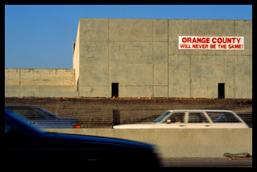
Major new urban centers, such as the burgeoning City of Irvine, were consuming the surrounding farmland, while the bedroom communities of Mission Viejo, Laguna Niguel, and Leisure World (now Laguna Woods) were rapidly expanding. The older adjacent communities of Tustin, Newport Beach, Dana Point, and Santa Ana were also seeing their formerly pastoral hills sprout homes, business centers, commercial strip malls, and numerous gated communities. was quietly working with county, state, and federal highway agencies to promote several major new roads to facilitate development. Included in these plans were California’s first toll way, the San Joaquin Hills Tollroad, and two additional toll roads, which would link the region from north to south, and east to west. As developers saw the gold in our hills and valleys, this sleepy part of Southern California was rapidly becoming identified as one of the fastest growing regions of the nation. Like many refugees from urbanity, we had chosen to settle in this small seaside community because of its relative isolation, as well as the unique topography that distinguished it from the monotonous homogeneity that was spreading across the inland flatlands. Laguna Canyon Road was our link to that larger world, but it was also the filter that protected our identity. This umbilical cord was about to become another Freeway and there was a redtiled tsunami following in its path – unless something was done.
To physically accomplish Phase I, we assembled a small crew of six people to sequentially photograph both sides of the entire nine-mile length of the road from the off ramp at the Santa Ana Freeway all the way into the Pacific Ocean. The resulting six hundred and forty-six frames per side were subsequently printed into twin color prints, each three and one half inches wide by two hundred and sixty-seven feet long. The pair of prints depicted our passage down the “last nine miles of the westward migration” in classic photographic detail. With this metaphor, we hoped to link the potential development of this still beautiful canyon with the concept of “progress in the West” and the danger of unchecked urban sprawl. We did not publicize our plans for this phase until we were already into the actual shooting and then only alerted a few reporters we felt we could trust, since we were concerned that the highway authorities might shut us down. This fear that was realized in subsequent phases (when we were actually threatened with arrest and ushered off the road), but we managed to successfully complete this first nine hour marathon without detection.
With the media success, we quickly came to realize that our work was as important as performance art as it was real documentation, and with Phase V: Primary Light Documentation, we took it to another level in both activity and concept. For this phase, we planned to “paint the canyon with light” which would take many more people, expensive equipment, and permits from every governmental agency that had any authority over the canyon or the highway. Before we could approach the authorities, we began by mobilizing further support within the region. With our growing army, we started lobbying regional environmental groups, the art community, and local public officials. Most were willing to endorse our plans, and some even offered financial assistance. By this time, the community was getting actively involved in the struggle to save the canyon, and we were seen as highly visible proponents of that effort…odd perhaps, but helpful to the cause. Besides, Laguna Beach had based its reputation on being an “artist colony” and even weird art had to be tolerated as a means of expression; and there would be the actual documentation that would provide a very accurate historical record of our last nine miles in a very unique fashion.
We finally put all the pieces in place, and on September 27, 1983, executed the Primary Light Documentation. That year, marking the tenth anniversary of BC Space, which had faithfully served as the fountainhead for our enterprises, seemed an auspicious occasion for this phase of the project. This was the most complicated phase to date, requiring a thirty thousand watt generator towed by a forty foot flatbed truck, sixty-five designated participants (plus an equal number in relief), thirteen vehicles, escort by three different police agencies and Caltrans officials. We had a ten-hour permit to complete the project and from 6pm to 6am , we moved this entire caravan methodically down the road taking one thousand and two hundred thirty-nine individual frames every thirty-three feet, every forty-five sections, until we completed the whole passage. The results were assembled into a single color print that was three and one half inches wide by five hundred and sixteen feet long, depicting the entire length of the Northeast side of Laguna Canyon Road. Given the nature and long-range planning necessary for this phase, the media was already well informed and the resulting press coverage included full pages in both the Los Angeles Times and the Orange County Register, plus good air time on regional television news. This was a terrific result, since we were already planning another, even more challenging project with Phase VIII: The Tell, a large scale mural in the land itself. This phase alone would require six more years of planning, significant fundraising, extensive lobbying, and marshalling even greater support.
We were enjoying some success exhibiting earlier phases at local art venues, but quickly found the limitation to exhibiting the results of the Primary Light piece. There was simply no easy method for presenting a five hundred and sixteen foot long print, but with the creation of the Time Machine For Moving Stills, we found a way. This thirty- six foot long motorized bridge provided a dramatic means of showing the entire sequence by having the images of the light painted roadside essentially commute for the viewer. This unique framing device caught the attention of museum curators and we were able to take Laguna Canyon on the road from Newport Harbor Art Museum (later to become OCMA), to Boulder Colorado’s Contemporary Museum, to Boston’s prestigious Photographic Resource Center. This was a great way to take our message on the road and significantly expand interest in our project, and the issues it addressed. This affirmation by the art world also gave us greater credibility in approaching the local bureaucrats, whose support we vitally needed. We finally had to stop the traveling shows, however. They were becoming very consumptive of our energies and resources, and we had a far more important venue in mind. Time was running out. Core samples were being taken for the first toll road path and the maps were drawn for the new city to be built in the canyon. As both were slated to begin construction in 1989, we needed to take the art out of the lofty realm of museums and galleries and bring it back to the public…and on to the road itself. The Tell was slipped past the scrutiny of the powerful development interests under the guise of a celebration of the 1989 Centennial of Orange County and the Sesquicentennial of the Discovery of Photography. After numerous setbacks, and clearing what seemed to be endless bureaucratic and political obstacles, we finally got permission to construct our mural in the canyon. It was appropriately situated directly across the road from the Irvine Company’s proposed Laguna Laurel housing project, and immediately adjacent to the designated pathway for the San Joaquin Toll Road, California’s first such debacle. The Tell became a six hundred and thirty-six foot long sculpture, which undulated through the landscape adjacent to the road, echoing the shape of the surrounding hillsides, and ranged in height from thirty-four feet near the road, to dwindle down into the ground in the distance. This enormous mural was comprised of thousands of individual photographs, mostly color snapshots, depicting all aspects of California life. Most importantly, this photo-mural resembled a giant reclining figure that could be seen echoed in the silhouette of the surrounding hills, and incorporated a stylized Easter Island head*. These highly personal images, all donated by Tell supporters, were rigorously assembled by content and character to fashion deeper stories about Man’s interaction with the Land, that were assembled by various themes within the chakra points of the figure. The story began at the far end from the road with abstract renditions of the Big Bang Theory and Starry Night, then evolved through early indigenous occupation, the Westward movement and on into current time…complete with projections for the future. It culminated near the road with the slightly vague outline of many people struggling to help the figure stand upright. The overall impression of the piece was of a giant pointillistic figurative painting with many tales within tales. Since an inherent characteristic of most photographic prints typical of that time is that they fade when subjected to such harsh conditions, we carefully tested how the various materials would change, and discovered that most of the donated color prints would predictably fade into an attractive sepia cast. This feature provided an intriguing kinetic aspect that we employed by carefully weaving the more over-arching philosophical messages in the mural out of longer-lived print material such as black and white or Cibachrome. The difference was not readily apparent in the beginning, but as time went on these images slowly emerged to dominate the story line. Just as the landscape itself changed from vibrant Spring colors to brown desert Fall, the individual life stories went from colorful and crisp in the early days to later fade into a sandstone colored web that held the more enduring collective messages together. This became another key component of the mural since most people were initially drawn to the artwork to see themselves represented; but in later visits, they found that their life stories had become a part of the greater whole telling another, more foreboding, tale.
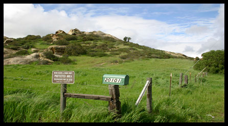
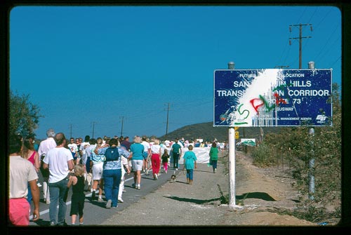
We were getting more adept at press releases and garnering coverage, and when this phase rose from local media to hit Life magazine and CNN, the level of interest multiplied dramatically. In the process of building this artwork, we were actually creating a focal point for the issues of the canyon, while simultaneously providing a catalyst for the battle to save it, and a megaphone to sound the alarm. Perhaps the most notable single event was held on November 11, 1989, when we coordinated with local environmental groups to host a march to the mural. For this event, over eleven thousand people walked six-and-a-half miles from the Festival of Arts in downtown Laguna Beach out to The Tell to demonstrate their desire to preserve Laguna Canyon in its more natural state. As a consequence of this public display, Donald Bren finally acceded to negotiate with the Cities of Irvine and Laguna Beach to release the land for public acquisition. In 1990, the residents of Laguna Beach overwhelmingly voted to tax themselves to buy it, and the canyon is now a key part of the Laguna Wilderness Park. A provision of this park is that it be preserved as Open Space in Perpetuity. What had begun as a rambling darkroom discourse over what we, as solitary artists, could do with the tools we had to help protect a valuable piece of our countryside, had evolved into a multi-phased, multi-dimensional project that ultimately helped to preserve that land beyond just the photographic scrapbook. Although encroachment is still a threat that demands constant vigilance, the road and its immediately surrounding hills are currently designated to remain undeveloped forever. That is a very long time, however, and we plan to continue to refine our art as a vehicle to inform and involve the public in the process of preservation…for as long as we are able to do so. Although The Tell* itself was destroyed in the wildfire of ’93, it has become a part of local folklore. A representation of a portion of it has been incorporated into the Nix Interpretive Center, which serves as the gateway to our sixty-two hundred acre Laguna Wilderness Park.
| ||